This blog guide provides comprehensive insights into the Annapurna Circuit Trek route map, helping trekkers understand the complete trail, major villages, altitude profile, road access, itinerary options, and side-trip connections. It also explains how the classic route starts near Besisahar, ascends through the Marsyangdi Valley to Manang, crosses the classic Thorong La Pass (5416 m), and takes a downhill walk into Kali Gandaki Valley to Muktinath, Jomsom, and Pokhara.
The guide also helps you distinguish trekking trails from jeep roads, compare 10-day, 12-day, and 15-day itinerary options, and identify popular extensions such as Tilicho Lake, Nar Phu Valley, Ghorepani–Poon Hill, and the Manaslu Circuit connection. Because road conditions, weather, and trail access can change quickly, use this route map alongside the latest local updates and follow the advice of a licensed trekking guide
Annapurna Circuit Trek Route Map Overview
The Annapurna Circuit Trek route map outlines Nepal's most classic trekking route: a loop around the Annapurna massif that links the Marsyangdi Valley, the high-altitude Manang region, the dramatic Thorong La Pass, and the Kali Gandaki Valley. The classic route starts near Besisahar, crosses Thorong La at 5416 m, and concludes near Pokhara via Muktinath Temple and Jomsom, extending to Poon Hill View Point, a full circuit.
A good route map helps trekkers visualize the trailhead and understand changing altitude, major overnight stops, road access, side trips, and key acclimatization points, so you can plan the adventure and stay safe. However, conditions and road access can change as per the weather situations, trekkers, should use the map alongside a current itinerary and trust guide completely.
What the Annapurna Circuit Map Shows
An Annapurna Circuit Trek map typically shows the main walking route, key villages, teahouse stops, altitude profile, river valleys, mountain passes, and even the trail connections, which give you an option to extend the itinerary to other trails, like the Manaslu Circuit, Nar Phu, and Upper Mustang. Besides, it also helps you understand where the route takes a gradual climb, where it becomes narrower and steeper, and where transport can replace several walking days.
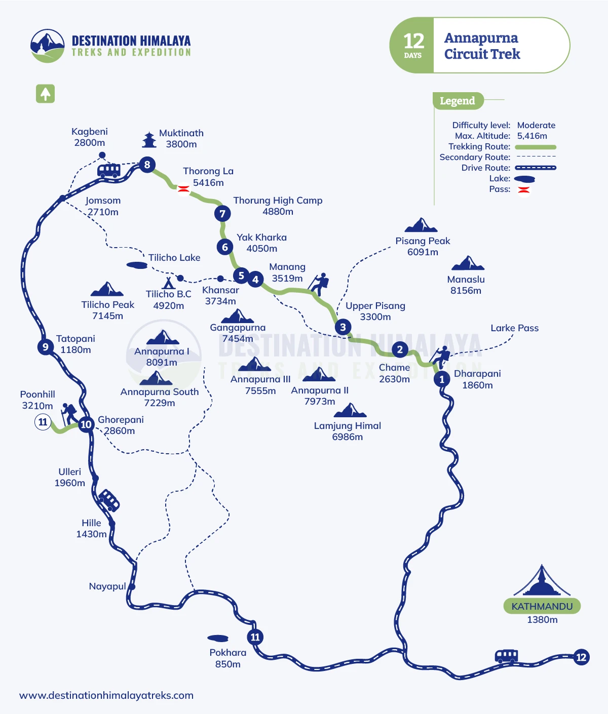
Standard Annapurna Circuit Map 12 Days
This regular standard map trekking route includes:
Main trekking route through Dharapani, Chame, Upper Pisang, Manang, Yak Kharka, Thorong High Camp, and Muktinath.
The highest point is marked as Thorong La Pass, at an elevation of 5416 meters.
Village and stopover elevations to help readers understand the changes in altitude.
Major mountain peaks, including Annapurna I, II, and III, Annapurna South, Gangapurna, Manaslu, and Pisang Peak.
Tilicho Lake side route, showing Khangsar and Tilicho Base Camp
Ghorepani and Poon Hill extension, with Poon Hill marked at 3,210 meters.
Driving routes connecting Kathmandu, the trail-access points, Jomsom, Tatopani, and Pokhara.
Alternative and connecting routes, shown as dashed lines, including a connection toward Larke Pass.
Map legend and orientation arrow explaining the symbols for trekking trails, roads, secondary routes, lakes, and passes
For planning purposes, the map is best viewed as a guide rather than a fixed itinerary. Trekkers may begin at Besisahar for the classic experience or take a jeep to Dharapani or Chame to shorten the route.
Why the Annapurna Circuit Is Usually Trekked Counter-Clockwise
The Annapurna Circuit is usually trekked counter-clockwise, as this direction provides a more gradual approach to the high pass of Thorong La, at 5416 m. Starting from the Marshyangdi Valley, the trail passes by Dharapani, Chame, Upper Pisang, and Manang before continuing toward Yak Kharka and Thorong Phedi or High Camp. This progression allows trekkers to spread the ascent over several days, rather than approach the pass directly from Muktinath.
The main advantage of this direction is that it gives an opportunity to spend an additional night in the famous Manang village before you move into the higher elevations. An acclimatization day allows time for a suitable local hike followed by a return to the same sleeping altitude. The route then continues through higher overnight stops before the pass crossing. However, following a counter-clockwise itinerary does not guarantee protection from altitude sickness; the pace and overnight stops must still suit each trekker’s condition.
The elevation markers on the trekking route map help explain why this direction is preferred. After descending from the pass, you reach the Mustang region — Muktinath Temple at 3880 m, while Thorong High Camp is marked at 4,880 meters. Approaching Thorong La from Muktinath would therefore require a much larger climb on the crossing day. The usual counter-clockwise route instead places that long, steep section on the descent toward Muktinath. Although this reduces the uphill effort on pass day, the descent remains demanding.
The Annapurna Circuit route takes an ascent through the Marsyangdi Valley, toward Manang, crosses Thorong La Pass, and descends into the Kali Gandaki Valley through Muktinath. However, depending on your itinerary, the journey can finish around Jomsom or continue to Tatopani, Ghorepani, and Poon Hill.
Besisahar to Chame: First Stage
Besisahar marks the traditional gateway to the Annapurna Circuit, or the starting point of the trek, where the route follows the Marsyangdi Valley through settlements such as Jagat and Dharapani, before reaching Chame, at 2632 meters. This lower section introduces the starting phase, a mid-arid forest area with pine and thick vegetation, before the upcoming days.
On the route map, you need to pay attention to the difference between the driving route and the walking trail itself. Many shorter itineraries use road transport to reach Dharapani or Chame rather than walking the entire approach from Besisahar. Your actual trekking starting point therefore depends on the package, itinerary, and the weather and road conditions, not simply on where the traditional circuit begins.
Chame to Manang: Second Stage
Beyond Chame, the trekking route then continues toward Pisang before reaching Manang. Around Pisang, the trail divides into main options: a lower trail through Humde and Braga and a higher trail through Ghyaru and Ngawal. These alternatives are useful map features because they explain why two itineraries can reach the same overnight stop while following different trekking trails.
The upper route involves additional climbing but also offers elevated views of the Annapurna range. The lower trail follows a direct line through the valley. Both lead toward Manang, a major overnight and acclimatization stop before the ascent toward Thorong La Pass. When comparing itineraries, check which Pisang- Manang route is included in the itinerary, rather than blindly being okay with just destination names
Manang to Thorong High Camp: Third Stage
From Manang, the main circuit climbs toward Yak Kharka, continues through Ledar, and reaches Thorong Phedi. Above Phedi lies the Thorong High Camp at an altitude of 4880 meters, as these residents mark the final approach to the pass and form some of the most important elevation points on the Annapurna Circuit route map.
An acclimatization day in Manang is crucial before you move to the higher altitude, as the itinerary then spreads the approach across overnight stops rather than treating Manang to High Camp as a single day trekking day. Some trekkers spend the final night at Thorong Phedi, while others continue to High Camp; the higher stop shall not be viewed as compulsory, as it appears on the trekking route map.
Thorong La Pass to Muktinath: The High-Pass Crossing
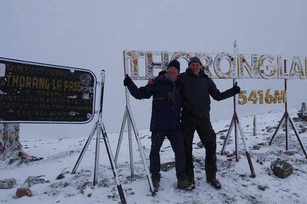
Situated at an altitude of 5416 m, the highest point of the Annapurna Circuit, the crossing begins from Thorong Phedi, or High Camp, climbs to the pass, and then descends toward Muktinath at an altitude of 3800 m. This links the Manang and Mustang regions trekking trail, but not a road connection. It is also one of the longest and most demanding stages, as it combines the high-altitude ascent with a substantial descent.
Muktinath to Jomsom: Fifth Stage
After the successful crossing, the route then takes a descent from Muktinath toward Jomsom into the Kali Gandaki Valley, where trekkers can include Kagbeni as part of this section, while shorter itineraries may use the vehicle route directly between Muktinath and Jomsom. This is where the map's walking and driving symbols become useful, as both forms either trekking or driving is possible. Jomsom lu an important decision point in the itinerary, as you can finish the trek here or extend the trail toward Tatopani for a full circuit to Poon View Point.
Tatopani to Ghorepani and Poon Hill: The Longer Route
For the itineraries continuing beyond Jomsom, the trail takes a drive to Tatopani before taking a climb to the viewpoint. Leaving the Tibetan-barren landscape, the trail enters the rhododendron forest, rivers, and the Magar and Gurung communities, reaching another iconic Annapurna viewpoint, Poon Hill (3210 m).
Annapurna Circuit Itinerary Options
10 Days Itinerary: Shortest Route
A 10-day Annapurna Circuit itinerary suits fit trekkers with limited time who are comfortable using road transport to skip the lower, road-heavy sections. It still includes the essential highlights: Manang, the acclimatization day, Thorong La Pass, Muktinath, and Jomsom.
Day 01: Arrival in Kathmandu (TIA - Tribhuvan International Airport), Transfer to Hotel, Pre-Trip Brief Meeting
Day 02: Take a drive (bus or jeep) to get to Besisahar, shared or Jeep drive to Chame (2670 m), total time: 8 hours
Day 03: Hike begins from Chame to Upper Pisang (3210 m), 05 hrs walk
Day 04: Upper Pisang to Manang Valley (3540 m), 5-6 hrs walk
Day 05: Acclimatizing and Side Trip (Hike), to Gangapurna Lake or Ice Lake (4610 m), 3-4 hrs round trip
Day 06: Manang to Yak Kharka (4052 m), 04 hrs walk
Day 07: Yak Kharka to Thorong High Camp (4860 m), 3-4 hrs walk
Day 08: Cross Thorong La Pass (5416 m, highest altitude), descend to Muktinath and then take a jeep drive to Jomsom Valley (2720 m), 9 hrs walk, 30 mins drive
Day 09: Take a drive to Pokhara from Jomsom, 7-8 hrs
Day 10: Ending the adventure, with a drive back to Kathmandu from Pokhara, 07 hrs
12 Days Itinerary: Standard Regular Route
A 12-day Annapurna Circuit itinerary ensures a better balance between time, daily walks, acclimatization, moderate walking, and more exposure to sightseeing, perfectly suitable for trekkers who want to complete the route without rushing, while still using jeep transfers for the road sections.
Day 01: Kathmandu to Besisahar or Jagat by road, 7-9 hrs drive (jeep or bus)
Day 02: Jagat to Dharapani (1860 m), 06 hrs
Day 03: Dharapani to Chame (2710 m), 5-6 hrs
Day 04: Chame to Upper Pisang (3240 m), 4-5 hrs
Day 05: Upper Pisang to Manang via Ghyaru or Ngawal (3542 m), 7-8 hrs
Day 06: Rest and Acclimatization Day in Manang (Optional hike)
Day 07: Manang to Yak Kharka (4052 m), 4-5 hrs
Day 08: Yak Kharka to Thorong Phedi (4450 m), 3-4 hrs
Day 09: Thorong Phedi to Muktinath via crossing Thorong La Pass, 9-10 hrs
Day 10: Muktinath to Kagbeni or Marpha (Drive), 3 hrs
Day 11: Marpha to Pokhara by road, or Jomsom to Pokhara by flight (Optional)
Day 12: Pokhara to Kathmandu by bus or flight
This version gives you one full acclimatization day at Manang and a more relaxed descent through the Kali Gandaki Valley. For a safer high-altitude schedule, sleep at Thorong Phedi rather than pushing directly to High Camp.
15 Days Itinerary: Luxury Comfort Extension Route
The 15-day Annapurna Circuit Luxury Trek is the most comfortable and complete way to explore the Annapurna region, allowing gradual altitude gain, a rest day in Manang, side trips, and the popular Poon Hill extension after crossing Thorong La Pass.
Day 01: Arriving in Kathmandu, Transfer to the 5-star hotel, and Evening Meeting with the team
Day 02: Kathmandu Sightseeing Tour (UNESCO Sites)
Day 03: Kathmandu to Besisahar (Private Jeep Drive), 06 hrs
Day 04: Besisahar to Bhratang (3-4 hours), Private Jeep Drive
Day 05: Bhratang to Upper Pisang (4-5 hrs), walk
Day 06: Upper Pisang to Manang, 7 hrs
Day 07: Acclimatizing and rest in Manang, a side trip to Ice Lake
Day 08: Manang to Yak Kharka, 3-4 hrs walk
Day 09: Yak Kharka to Thorong Phedi, 04 hrs
Day 10: Crossing Thorong La Pass, downhill walk to Muktinath, 9-10 hrs
Day 11: Private Jeep Drive to Ghorepani via Tadapani, 6-hour walk
Day 12: Morning Hike to Poon Hill View Point, 3210 m, downhill hike to Banthanti, and drive to Pokhara, 2.5 hrs walk, 3 hrs drive
Day 13: Pokhara Sightseeing Tour and Flight back to Kathmandu in the Evening
Day 14: Free Day in Kathmandu (Sightseeing Tour)
Day 15: Final Departure Day
Bestly suited for the families with kids, and senior citizens, or those having more time to spend in Nepal.
Alternative Trails and Side Trips on the Map
The Annapurna Circuit route map helps you identify alternative walking trails, as well as side lake excursions during side trips, and connections to nearby trekking regions. Some options include the upper route through Ghyaru and Ngawal into the main circuit. Others, including Tilicho Lake, Nar Phu Valley, Manaslu, and Upper Pisang, demand prior experience, longer trekking hours and days, or a separate trekking itinerary. These connections should be treated as optional trekking routes rather than standard inclusions in every Annapurna Circuit package.
Upper Pisang Route and the Trail Through Ghyaru and Ngawal
Between Pisang and Manang, the upper trailhead passes by Ghyaru and Ngawal, providing an alternative to the lower valley route. This extension involves additional climbing; however, it rewards trekkers with great, distinct mountain views and opportunities to walk through Tibetan settlements. It branches toward Ghyaru, before continuing through Ghyaru and then through Ngawal toward Manang. It is an alternative section of the main circuit rather than a separate out-and-back extension.
Tilicho Lake Extension
The Tilicho Lake extension branches from the main circuit near Manang valley and follows the trail via Khangsar, Siri Kharka, and Tilicho Base Camp. From the base camp, you will then make an uphill walk toward the lake, which lies at an altitude of 4919 meters; this excursion adds a high-altitude lake experience before the trek continues toward the pass. On the map, follow this as a distinct branch rather than the direct straight route, Manang- Yak Kharka. Visiting the lake, demand extra 3-4 days of trekking days, and a planned return connection to the main circuit.
Ghorepani and Poon Hill Extension
The Poon Hill extension adds a southern trekking section after crossing the high pass of Thorong La. Rather than concluding the trip around the Jomsom valley, the itinerary continues toward Tatopani before climbing through villages and forest toward Ghorepani. From there, trekkers can visit Poon Hill before taking a downhill walk to the lower trails before getting back to Pokhara. This extension offers a different landscape from the high-altitude Manang and Mustang sections. When reading the map, distinguish the road transfer toward Tatopani from the walking trail to Ghorepani.
Nar Phu Valley Extension from Koto
The Annapurna Circuit and Nar Phu Valley: explores a separate valley system, rather than following the direct route, toward Pisang and Manang Valley. On a broader trekking map, Koto is therefore the key junction to identify when considering this extension. The Nar Phu addition is a longer itinerary, not a short side trip, along the standard Annapurna Circuit trail. The extension demands a separate restricted-area permit and advance arrangements through a registered trekking agency. Your itinerary should clearly show the valley excursion and its connection back to the Annapurna route rather than presenting Nar Phu as an included stop on a regular circuit trek.
Manaslu Circuit Connection at Dharapani
The Manaslu Annapurna Circuit Trek connects the two major passes of Thorong La and Larkya La. Firstly, you cover Manaslu and then connect the trail from Dharapani, making it possible to combine two popular treks in a single itinerary. On a regional map, the connection toward Larke Pass indicates the neighboring Manaslu route; it does not mean that the pass belongs to the Annapurna Circuit. A combined itinerary requires considerably more time and separate permits for the Manaslu region, alongside the relevant Annapurna permissions.
Road Access and Transport Connections
Road access allows trekkers to adjust the Annapurna Circuit's starting point, shorten lower-valley sections, and arrange transfers after crossing the pass of Thorong La. When reading the route map, distinguish the driving sections from the walking trekking trails; the itinerary connecting two villages does not necessarily mean that you will trek the entire distance between them. The main approaches follow the Marshyangdi Valley on the east side, and then the valley of Kali Gandaki.
Getting to the Trailhead from Kathmandu or Pokhara
Most road journeys to the Annapurna Circuit start with a bus or jeep ride from Kathmandu or Pokhara to Besisahar. From there, the trekking route follows the road highway toward Khaireni and Dumre, turning into the Marshyangdi Valley. Buses and private jeeps can get you there easily, whereas from Besisahar, the road condition is bumpy and off-road.
From Besisahar, the roadway continues through the lower valley, toward Dharapani and Chame; however, your itinerary determines where the drive ends and the walking trail starts. Starting lower on the trail allows trekkers to explore the trail exclusively, adjusted to the rising elevation, while a jeep transfer to Dharapani or Chame reduces the number of further trekking days. The road from Besisahar includes narrow, uneven, and rugged sections, so the travel time can be slower and less gradual on the trekking map.
Road Transfers around Jomsom and Tatopani
On the western side of the circuit, road connections link the Muktinath Temple and Jomsom - Mustang region, with the lower Kali Gandaki Valley, and continue toward Pokhara by road. After crossing the pass of Thorong La, trekkers can choose between continuing on foot, using road transport, or combining both. These transfers are important for itineraries that focus on the region of Manang, and then the high-pass crossing rather than having to walk the entire lower section. For the longer route, that includes Ghorepani- Poon Hill, the trail follows toward Tatopani before returning to the walking trailhead.
For a route that includes Ghorepani and Poon Hill, a common arrangement is to travel south toward Tatopani before returning to the walking trail. This avoids treating the entire Jomsom–Tatopani connection as a trekking stage. The road access does not simply guarantee a quick transfer, as the Himalayan road conditions can change, so make sure to confirm the latest access information locally rather than relying only on a printed trekking map. Rather, stay updated through the trekking agency and the guide.
Returning to Pokhara After the Trek
Your journey back to Pokhara depends on where you finish trekking. If you end at Jomsom, the onward journey follows the road through the Kali Gandaki Valley. If your itinerary includes Ghorepani and Poon Hill, you continue on foot to a lower trailhead before taking a vehicle to Pokhara.
For routes ending at Nayapul, the remaining journey to Pokhara is completed by road. Check your itinerary for the exact pickup point, transport type, and whether the transfer is included in the package price. A trip described as “ending in Pokhara” may finish its walking section elsewhere, with a drive covering the final stretch.
When reviewing the Annapurna Circuit route map, pay attention to the separate markings for roads and walking trails. The line leading back to Pokhara may represent a vehicle transfer rather than a trekking stage. Understanding this distinction helps you compare itineraries and see how much of the journey you will actually cover on foot.
Annapurna Circuit Road Condition: Updated Information
The road access has changed the Annapurna Circuit; however, it has not removed the overall trekking experience. Vehicles can reach much of the lower Marsyangdi Valley and the Kali Gandaki Valley, while the high elevation section from Manang over Thorong La Pass to Muktinath Temple remains completely road-free.
Current Road Status on the Annapurna Circuit
A motorable road now extends from Besisahar to Chame, even up to Manang Valley, while another road connects Muktinath Temple, Jomsom, Tatopani, and Beni on the western part. Public buses operate exclusively between Besisahar and Chame, and jeeps continue toward Manang when the road is open.
Despite this, there is no road across Thorong La (5,416 m). Every trekker must walk from Manang through Yak Kharka and Thorong Phedi, cross the pass, and descend to Muktinath.
Latest Update: Besisahar–Chame and Jomsom Roads
As of November 2026, the Besisahar- Chame road has reopened after landslide-related closures during early October 2026; however, the road was reopened on October 3, allowing trekkers to get access to the classic trail of the Annapurna Circuit. However, the road conditions may vary as per the seasonal time. The road and bridge conditions beyond Chame toward Bhratang and Manang can change instantly after precipitation or any weather disruption. On the Mustang side, which you will reach after crossing the pass, the Beni to Jomsom road was damaged during late Autumn, but currently it is reported to be repaired and open by November, 2026.
Note: Get a recent update on the road conditions before departure, with the company and with the guide, during the trekking trails.