Where is Thorong La Pass located?
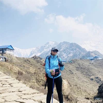
Protected by the Annapurna Conservation Area Project (ACAP), the Thorong La Pass is located at the northern side of the Annapurna Himal, in the central part of Nepal, which soars at an elevation of 5416 meters (17,769 feet), marking itself as the world's highest pass. Known as the world's highest walkable pass, it is adorned with the prayer flags, fluttering speedily in the high altitude winds, and the Buddhist chortens (stupas), with a sign board of the pass, mentioning its elevation, welcoming the visitors, to the almighty pass of Throung La, with its heavenly beauty.
Residing in the Manang district, it connects the Mustang region to the east with Muktinath Temple, after descending from the high pass, and the village of Ranipauwa, to the west, marked by the world's deepest gorge of Kali Gandaki. Trekking to this pass is a physical adrenaline-boasting adventure that demands your patience, persistence, consistency, and careful navigation, with intellectually planned acclimatization days, to avoid any possible risk that the high elevation possesses. Residing at the fringe of the Damodar Himal, it sits at 28.8024 N longitude and 83.9418 E latitude, geographically, and in present days, acts as one of the most prominent places to visit in Nepal, offering a rich Tibetan cultural experience, and the distinct perspective of the Himalayas and the surrounding mountains.
What are the Major Attractions of the Thorong La Pass Trek: Why It stands out in 2026 and 2027?
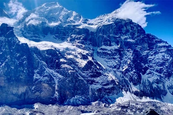
- Unmatched Himalayan Peaks Insights: Experience the accompaniment of several mountains, such as Manaslu, Gangapurna, Tilicho Peak, Gangapurna, Lamjung Himal, etc, in each step, whereas, get surrounded by the panoramic view of the Annapurna and Dhaulagiri range, with the distinct fusion of the Tibetan plateau landscapes and alpine.
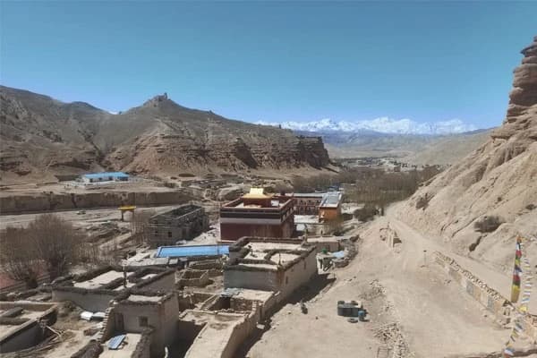
- Cultural Exploration: Navigate through several Tibetan hamlets, and unravel the cultures of Gurung, Magar, Thakali, warm hospitality, unique way of livelihood, and cultural celebrations, insighting how such locals reside at such high elevation, without being modern influenced.
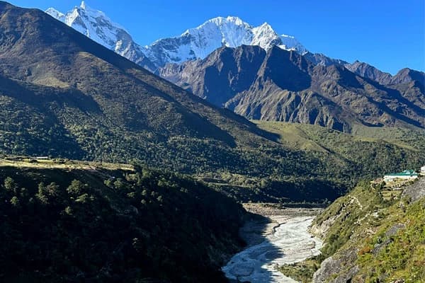
- Annapurna Conservation Area: Trail through Nepal's largest protected area, overlooking the other parts of the Himalayas, such as thriving, lush green valleys with the rhododendrons, pines, cascading, roaring waters, wetlands, alpine valleys, and rough and rugged terrains. dry Tibetan landscapes, in each turn, rather than just viewing the 360-degree views of the mountains.
- Off Beaten Wild Adventure: Venture out on the thrilling, wild, challenging adventure, exploring the less trodden ancient trailheads, feeling the serenity of walking through the less crowded route, far from the crowded hikers, where the tranquility soars louder than people's noises.
- Spiritual Sites: Visit the religious holy Tilicho Lake, en route, which carries a spiritual significance to locals, and the famous Hindu Muktinath Temple, known for Buddhism and Hinduism, a primary spot in Nepal.
- World's highest walkable pass: Ace the new height this year 2026, by reaching the pinnacle of the world's highest walkable pass of Thorong La at 5416 meters.
- Luxury Blending with Remoteness: Enjoy the luxury adventure to the Annapurna circuit, route to the high pass, where the remote amenities are gradually progressing to the luxury tea houses, lodges, and amenities, catering to every kind of adventure seekers across the globe.
How high is Thorong La Pass in Nepal?
Thorong La Pass resides at an elevation of 5416 meters (16,752 feet), which stands as the world's highest walkable pass, along with the highest elevation point of the classic trek to Annapurna Circuit. Soared at such a high altitude above sea level, reaching here requires, long distance coverage, preparations and intelectually planned acclimatization day, with gradual ascend, which supports to the fact, that Thorong La, is one of the challenging, longest, however, not technically demanding mountains passes in the Himalayas, just as Larkya La, which is a part of the Manaslu Trek.
The everyday elevation gain can be brutal to some, if the novice hiker is speeding up the pace level, and willing to complete the overall trip, in shorter days, remember, that, as you go higher, the air gets thinner, with minimum oxygen level, that's how the himalayan trail leads, you and the way to succeed in slow, steady, like a turtle, and not rapiding up, like rabbit, just take it an instance of the famous Rabbit and Turtle racing story, and to be honest, that's what trekking to the high elevation is like.
Before reaching the highest altitude of the Annapurna circuit trail, there are many key stopping points, where you can rest, acclimatize, or take a short trip, whereas, if you are considering the regular standard route, then the best place to acclimatize is at Manang (3,538 meters). While acclimatizing, the best way, to adopt the rising elevation is that, to engage in short hike, to Gangapurna Lake, Ice Lake, or Lama Cave, that is just few hours distance, just 3-5 hours of hike and a matter of time, ascending just higher, so, on the following days, while, you move towards, Yak Kharka (4050 m), Thorung High Camp (4880 m), your body gets adjust to the high altitude, accordingly, that's what I did, and it worked great.
While approaching the pass of Thorong La, it is a wild, strenuous, moving steadily, planned itinerary, and acclimatizing well, contributes highly to making the overall ascent to the highest elevation of the Annapurna Circuit easier and smoother.
How hard is Thorong La Pass?
The trek to Thorong La Pass is a difficult adventure because it demands a long duration hike, a high patience level, medically fit conditions, and, at the same time, proper planning and acclimatization. One of the major factors that makes the journey to the high pass challenging is the high elevation itself, at 5416 meters (17,769 ft), where the air gets thinner, and oxygen is less than our body is used to, in the city area, thus. That is why proper acclimatization days and gradual ascent are required. While following the well-planned itinerary, one can get the risk of mild altitude sickness, where the symptoms, such as mild headache, a sort of dizziness, and discomfort, difficulty breathing, like normal days; however, make sure to check with an oximeter, whether the pulse rate is normal or not. To avoid such risks, ensure that you follow the safe preventive guidelines from the very start of the journey.
The route to the Thorong La Pass is not technically demanding, yet you must be careful and navigate steadily, following the assistance of the licensed trekking guide, and proceed on the journey to the pass by 4:00 AM to avoid the heavy winds and the possible risk of avalanches in the evening. The day when it finally comes to making your ascent to the high pass, it checks your testaments, with the longest hour of hiking, lasting for 8-10 hours, which is the longest distance trekking coverage of the overall adventure. The trailhead navigates through several steep sections, a continuous uphill walk, and a descent of 3-4 hours towards Muktinath, from the pass, touching the Mustang region of Nepal, where there are almost zero tea houses, in between, and the route comprises icy, steep, and slippery pathways, which makes the overall ascend to the pass of Throung La challenging.
Physical Testament: How to be prepared?
Crossing Thorong La Pass is physically demanding as well, along with requiring high altitude navigation each day, as throughout the journey, it passes through varied kind of terrains, while some days, you have to pass by the lush green valley, villages, the other day, the route changes to rugged, remote, and thin tree line, areas, making the navigation challenging. The daily hike this trek demands is approximately 5 to 6 hours, covering from 8 to 12 kilometers, through several ascents and downhill walks, via a steep and not well-marked route, which requires a strong fitness level, or basic ones, who can undertake, least 4-5 hours of walking distance per day. The longest navigation stands out to be the ascent to the pass, where the continuous, uphill walk, and icy pathways, for 7-8 hours, make the day challenging, with a descent of 2-3 hrs to Muktinath Temple, followed by rugged and dry pathways.
To make yourself physically prepared, engage in cardiovascular exercises, such as walking, incline ascend, running on a treadmill, cycling, swimming, or muscle training as well, like squats, dumbbells, back workouts, and even leg press, to strengthen your muscles and stamina level. Whereas, if you are not a gym freak, then you can engage in home workouts, or short hikes nearby, or just hit the 10,000 steps, walk, tracking via i watch, every day, or just run or walk via staircase, carrying a backpack, to make your legs strong, and breathe in ease.
Mental Testament: How to be prepared?
Besides being physically challenging, the Thorong La Pass Trek is mentally challenging as well, demanding a high level of patience, and one must be prepared for unexpected situations like weather challenges, possible risk of AMS, changes in pathways, and the remote amenities, no matter how beginner or experienced you are. Please, take a note that, your mental health plays a vital role, on how your body reacts at the high elevation, so setting a positive mindset with high determination and patience level is crucial, so you are not only strong in physique, but also, at the same time, your mind set, is strong enough to overcome any kind of possible challenges. The amenities along the route are not so well facilitated or developed. Basic amenities, like washrooms, bedding, wifi, and even charging sockets, are luxuries at high elevations, so keep the realistic expectations accordingly and be prepared accordingly.
Mental preparedness consists of researching the trailhead that you will navigate at, the packing considerations done, as per the route, elevation, and amenities available up there. To corporate your mind strongly, you can download, the motivational playlist at spotify, download podcasts, of the trekkers, climbers, mountainneers to keep you persisent, and with the personal experience, I suggest you to do medidation, before and after the trip, and even yogas, reflecting your mind and soul, so that your mind remains composed, peace, and keeps you consistent thoroughly, with positive affirmation.
Note: To know more, regarding the challenges, and tips to be prepared accordingly, you can take a detailed insight into our recently updated blog on how to be prepared to ace the Annapurna Trail, conquering the pass, with ease and smoothly.
How to Reach Thorong La Pass: Standard Routes, Alternative Paths, and Starting Points
Standard Route from Kathmandu: How to begin?
Route: Kathmandu - Dharapani - Chame - Upper Pisang - Manang - Yak Kharka - Thorung High Camp - Thorong La Pass - Muktinath Temple - Tatopani - Ghorepani - Pokhara - Kathmandu
Starting from Kathmandu, the capital city of Nepal, is the regular starting point for any kind of Himalayan adventure, and the same goes with Annapurna Circuit Trek, which starts with a road drive to Dharapani through a local bus, private jeep, or sharing one, with a 7-8 hour drive. The starting point of the trekking trail marks the Dharapani, towards Chame (2630 m), and passes through the notable stopping points such as Upper Pisang (3310 m), Manang (3538 m), Yak Kharka (4050 m), and Thorung High Camp, and ascends to the highest elevation of the Thorong La Pass (5416 m).
As you can witness, by the overview itself, that each day, you go higher, with thinning air and less oxygen, where you will gain more than 3000 meters from the beginning point, that is why one acclimatization day is required, in between, and the famous acclimatization point is the Manang at 3530 meters, which was the ancient trading route between Nepal and Tibet. During this rest day, you can take a short excursion to Gangapurna Lake, or Ice Lake, so that your body gets used to the rising high altitude, as the short hike supports your body to adapt to the increasing elevation.
After taking an ascent to the Thorung La Pass, the highest walkable pass in the world, the trail connects to the Mustang region, at the Muktinath Temple (3800 m), then it leads you to the famous viewpoint of Annapurna region, at the Ghorepani Poon Hill, which is a distinct trekking route, which means, you will cover another iconic spot as well. Followed by a drive towards Pokhara (860 m) by a jeep, the regular route ends after returning to Kathmandu, within 12 days of the timeframe.
Getting to Thorong La Pass from Pokhara: Another Starting Point
Route: Pokhara - Besisahar - Chame - Upper Pisang - Manang - Yak Kharka - Thorung Phedi - Muktinath - Jomsom - back to Pokhara
A bus ride or a private or sharing jeep from Pokhara (830 m) to Besisahar leads you to the starting point of the Annapurna Circuit Trek from Pokhara, with just 6-7 hours, where you can take a direct hike to Chame (2630 meters), on the very first day, if you are in good fitness shape. Just like the regular standard route, the trailhead navigates through Upper Pisang, Manang, Yak Kharka, Thorung High Camp, and crosses the high pass of Thorong La, then takes a descent to Muktinath Temple, Jomsom, following the world's deepest gorge of Kali Gandaki Valley. From here, you return to Pokhara via flight of 25 minutes, or a jeep ride 4 to 5-hour jeep ride, depending on the weather conditions and traffic congestion.
Combining with other Trailheads
Apart from following the standard route, there are other alternative pathways to reach the Thorong La Pass, as well, by connecting the ancient exploration trek to the twin valley of Nar and Phu, which demands an extended trek, and more preparedness and physical stamina. Starting from Kathmandu, the route to the combined trek to Annapurna Circuit with Nar Phu Valley, towards Jagat, and then follows the walking trailhead to Dharapani, Meta, Kota, and then Phu Gaon, which includes one acclimatization day at Phu, with a side excursion to Himlung Himal Base Camp at 4250 m, or Tashi Lakhang Monastery.
Navigating further, the route navigates to the cross over of Kang La Pass at 5320 meters, and then takes a downhill walk to Ngawal and Manang, where one acclimatization day is required as well, before crossing another high pass. Proceeding further to Yak Kharka and Thorung High Camp, it finally leads you to the highest elevation of the pass of Thorung La at 5416 meters, then, afterwards, connects with the Mustang region, touching the Muktinath Temple, after a descent.
Whereas, another famous alternative pathway, to reach Thorong La Pass, is marked to cover the Manaslu Circuit and Annapurna Circuit Trek, in one adventure, which almost demands 19-20 days in total, covering the restricted area. Starting with a drive from Kathmandu (1360 m), towards Maccha Khola via Aarughat, it traverses through several key points villages such as Jagat, Deng, Namrung, Lho Gaun, Sama Gaon, Samdo, Dharamsala, and finally crosses the Larkya La Pass, and takes a downhill walk to Bhimthang, and Chame, joining the route of the Annapurna circuit trail.
When is the Best Time to Visit Annapurna Thorong La Pass: Weather and Views
Just like other treks in Nepal, the best time for trekking in the Thorong La Pass stands out to be Spring, starting from mid-March till the end of May, and Autumn from September to mid-November, as during this time frame, the weather and temperature blend perfectly, contributing to the best views and dry trails to navigate with ease. During this span of the year, the idyllic climatic conditions offer mild humidity, where you can trail along, without being drained physically or mentally. The stable weather situations, with a lower level of precipitation, are where you can cross the high pass, without having to walk through the snowy pathways and wet terrains, without demanding any technical climbs or expensive snow navigation gear.
While during the spring season, you can expect the lush green valleys, thriving with the red and pink rhododendrons, dry terrains to step in, and the crystal clear views of the several peaks, including Annapurna I (8091 m), Dhaulagiri massif, Manaslu (8163 m), Annapurna II, Cheo Himal, Lamjung Himal, and distinct vista of the landscapes. Autumn, season, on the other hand, presents the panoramic fish lens views of the mountains, with the green valleys, roaring sound of cascading waterfalls, and the forested area, which seems like autumn, where leaves are crusty brown, making the route even more enchanting.
Meanwhile, crossing Thorong La Pass, in winter (December to February) and monsoon (June to August), is a nightmare, and brutal, where the continuous amount of rain showers and snowfall makes the route challenging to navigate, demanding high fitness level, than normal, gears like crampons, and even ropes, also, contigency days (extra 2-3 days), as sometimes, the way to the pass, might be blocked by the government for the safe ascend. Hence, the best time to visit the pass marks to be either spring or autumn, due to ideal weather and great views, which you get to glance at each step.
What permits are required for the Thorong La Pass in Nepal?
To visit Annapurna Thorong La Pass, the required trekking permits stand out to be the Annapurna Conservation Area Permit (ACAP), whereas the TIMS Card (Trekkers' Information Management System Card), on the other hand, isn't required since 2023 A.D. This permit is compulsory to get access to the trailhead of the Annapurna Circuit trail, where the money spent on, directly goes to conserve the wildlife and cultures of locals, along with boosting the economy of the locals, which is mandatory and checked at the entry points along with many other stopping points as well.
The cost for the permits to get access to the Annapurna Conservation Area, where the Thorong La pass resides, is checked at many stopping points such as Besisahar, Chame, and Manang, and even while descending to the Mustang region, from the high pass; hence, make sure to carry permits with you all along. You can get the required permit at NTB (Nepal Tourism Board), at either Kathmandu or Pokhara, whereas, if you are hiking with a guided company like us at Destination Himalaya Treks and Expedition, then the required permits will be arranged, with other logistics. The cost for the Annapurna Conservation Area Permit (ACAP), is only USD 30, that is NPR 3200, approximately, whereas if you are combining this trip with others like Upper Mustang, Nar Phu, or others, then additional permits are required.
Safety Tips for Crossing Thorong La Pass, Nepal
- Start the hike earlier, at around 3:30 AM to 4:00 AM, so that you can reach the high pass earlier, and descend before 2:00 PM, to avoid the heavy winds, high snowstorms, and also get the best unhindered views of the mountains.
- Make sure to acclimatize properly before ascending to a higher altitude, or set aside at least 1 acclimatization day, before crossing the pass of Thorong La at Manang (3500 m), so that your body gets adapted to the rising high elevation. If possible, try to set 1 more acclimatization day at Thorong Phedi, as well; setting 2 acclimatization days is crucial.
- Hydrate yourself with at least 3-4 liters of water per day, avoiding dehydration. If drinking that many liters sounds too much, then consider having hot soups like garlic soup, ginger soup, and consuming nutritious foods to maintain your strength level.
- Before crossing, make sure to check the weather forecast, know the climatic conditions, and avoid ascending if anything doesn't seem normal, like storm warnings or avalanche possibilities.
- Do not undertake the hike alone, independently, without the assistance of a registered local guide, as trekking solo isn't allowed, as the guide will lead you through the safe terrains, and also assist you if any uncertain medical emergency occurs.
- Consider packing all four seasonal variations, carrying the gears and essentials, matching all four seasons. For instance, if you are hiking in the summer, autumn, or springtime, consider bringing moisture-wicking clothes, along with jackets (down or puffer ones), and even a sleeping bag.
- Do not miss out on grabbing a good travel insurance policy that includes all the essentials, such as theft, trip, cancellation, and delays of the trek, and most importantly, the medical coverage and helicopter evacuation over 3000 meters.
- Make sure to carry the health essentials like, oximeter - to check the pulse rate, a first aid med kit, and a water purification tablet, and monitor your oxygen level and pulse rate at each stopping point.
- Use sunglasses while navigating to avoid the snow glare, and also, sunscreen with SPF 40+ to avoid sunburn.
FAQS (Frequently Asked Questions)
Which is the highest walkable pass in the world?
Thorong La Pass marks the highest walkable pass in the world, that soars at an elevation of 5416 m *17,768 in feet), connecting the two districts of Manang and Mustang, protected by the Annapurna Conservation Area.
Do I need a guide or porter for the Thorong La Pass trek?
Yes, a registered licensed trekking guide, is required for the assistance, and has been mandatory, to get access to the thorong la pass, for safe navigation, whereas, the porter isn't compulsory, as it depends on you, or for to trek in budget you can consider a porter guide, who works as a trekking guide, and carry your loaded backpack.
Can beginners trek to Thorong La Pass?
No, Annapurna Circuit is not recommended for beginners, as it takes an ascent to higher altitude each day, demands long trekking hours, duration, distance coverage, and challenging navigation.
How many days does it take to reach the pass of Thorung La?
Usually, the Annapurna circuit trek takes between 12 to 14 days, demanding 2 additional acclimatization days in between, starting from Kathmandu, whereas, if you want it rapidly, and are an experienced hiker, then this short trek to the Annapurna circuit only takes between 8 to 10 days.
Is Thorong La Pass harder than Everest Base Camp?
Compared to the Everest Base Camp (EBC), the trek to the Annapurna circuit is challenging, due to not-so-well-marked trails, rugged terrains, and remote trailheads; however, in terms of accessibility, the EBC is more challenging and reaches the highest altitude at 5545 meters, at Kala Patthar.
Conclusion: Final Words
Thorong La Pass, at 5416 meters, is one of the most thrilling adrenaline-boasting adventures, taking you to the amid the beauty of the highlands, following the classic off-beaten route, and attaining the highest walkable pass in the world, Thorung La, where the perfect fusion of the dry Tibetan plateau, with the surrounding panorama of the Annapurna and Dhaulagiri massif.
Touching the two major districts of the Manang and Mustang region of Nepal, and the trailhead, passing through a variety of terrains, the crossing over to the high pass demands ample preparation, long hours of trekking distance, a proper physical fitness level, acclimatization days, well-planned itinerary. Thus, if you are planning to trek to Thorong La Pass, or you can say the classic Annapura Circuit, then we at Destination Himalaya Treks are all set to assist you safely, covering the best iconic spots, to the iconic pass. With an experience of more than 15+ years, we are set to lead you to the world's highest pass, with ease, comfort, with your personalized itinerary according to your budget. If you have any queries, then, feel free to contact us via call, or whats app at +977 9851016814, or just mail at [email protected], anytime.