What are the Three High Passes?
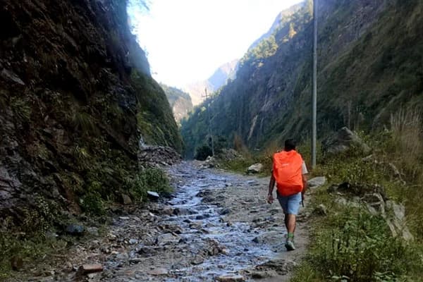
The Three High Passes refers to one of the most legendary adventorous trekking routes in the Everest region, which leads you to the crossing of 3 everest pinnacles, which soar at an altitude of 5000 meters. It is the trailhead that is linked with the base camp of the world's highest peak, Mount Everest (8848.88 m), EBC, and also, the untamed pristine emerald series of Gokyo lakes. However, for those who have already done the Everest Base Camp Trek, can avoid reaching here, and diverge from the way from Lobuche to other passes.
The three ultimate mountain passes stand out as Kongma La, Cho La and Renjo La, each offering a unique perspective of the giant Himalayan peaks, glaciers, and landscapes. The highest and most difficult pass, among the 3 marks, is Kongma La Pass, which is perched at an altitude of 5535 meters, where the terrain navigates via rocky, steep and rugged sections. In contrast, the other two passes are less challenging, which is why some people only tend to root for either Renjo La and Gokyo, Cho La EBC and Gokyo Ri, avoiding the other one, especially for beginners.
Renjo La Pass (5360 meters)
The Renjo La Pass sits at an altitude of 5360 m (17,558 feet), which is the lowest high pass, among the trio, that connects the Gokyo route to Thame or Lungden, which takes almost 6 hours covering 10-11 km, with a steep climb from Gokyo (4790 m), and a descent of 890 meters. A rocky climb takes you to the steep stone pathway at the end of the climb, which guides you across. From Renjo La, you gain access to one of the Himalayas' top-tier perspectives, which includes the remarkable mountaintop formation of Everest, Lhotse, Makalu and Cho Oyu and the sparkling Gokyo Lakes shimmering like precious blue jewels before descending to the peaceful Thame Valley.
When compared to the other two passes, it is considered the easiest one, and beginner-friendly, which doesn't include any glacier, icy or strenuous sections; however, a rocky ascent is expected, so ensure to have at least a basic level of fitness. If you have no prior high-altitude experience, you can consider only the Gokyo to Renjola Pass Trek and avoid Kongma and Cho La. Whereas, for the full circuit, you'll come across the pass of Renjola first, helping your body acclimatise to the rising high altitude, and proceed to the other pinnacles gradually, on the other half.
Cho La Pass (5420 meters)
Cho La Pass, is one of the high altitude Everest's mountain pass, that sits at an altitude of 5420 m (17,782 feet), within the Sagarmatha National Park itself, just like, others, that you will come across, while on the trail, from Dzongla (4830 m) to Thagnak (4700 m), forming a major segment of the Gokyo route and the 3 pass route. Compared to Renjo La, it is quite strenuous, and involves steep icy sections, rocky pathways, and longer to cross over, demanding 7-9 hrs of hiking. It is not technical as well; however, in case of heavy precipitation (at peak seasons), the crossover becomes challenging, as you will face slippery slopes and high winds, which require crampons and prior experience.
The trail connects the Gokyo Valley to the main Everest Base Camp route, which passes through Cho La, leading from Dzongla and Thangnak through a stone valley to reach an elevation where you must navigate past enormous rocks. It becomes the most challenging to cross the tiny glacier at the summit because it turns very slippery during the morning hours. Most hikers need between 7 and 8 hours to walk through this pass, usually starting their journey in the early morning to ensure safety.
At the top of Cho La pass, prayer flags welcome you with breathtaking mountain panorama views, including Ama Dablam, Everest, Lhotse, and Ngozumpa glacier. The downward trail starts steeply before transitioning into a part filled with loose rocks, then comes easier sections when descending toward Thangnak and ultimately reaching Lobuche, connecting the route with the base camp and Kala Patthar, on the very next day.

Kongma La Pass (5535 m)
Kongma La stands both as the highest, most challenging and the last pass that you will come across along the trail, reaching elevations between 5535 meters and 5550 meters, connecting Chhukung of Imja valley to Lobuche, which takes approx. 8-10 hours with a steep climb of 800 meters via rocky moraine and a sharp descent. Considered the toughest pass, due to long distance coverage, high exposure, high elevation, rugged pathway and isolated section, it is harder than Cho La and Renjo La. Even though it is the demanding one, it is the last one that you'll come across, and as the day comes to conquer, you have already achieved the two passes, making the hardest one attainable with ease, with adaptation to the rising altitude.
Most hikers begin their journey either from Lobuche or Chukhung, while the day starts before sunrise to tackle the length of the route. The path ascends continuously through empty landscapes which contain mainly rocks, with the view of ice formations as you walk beside the Khumbu Glacier and hear its loud creaking sounds as it moves.
At the top, where prayer flags create colourful decoration, you will see Island Peak, Makalu and Ama Dablam peaks. Moving down becomes difficult because the trail consists of steep terrain with loose rocks that lead to Chukhung Valley. Kongma La becomes the most challenging pass for trekkers due to its elevation and an extended 8-9-hour single-day walking route. However, those with prior preparations reach this pinnacle and the top seemlessly. You just need to be well prepared, follow the safety guidelines of the mountains throughout, and you're good to go.
Full Circuit Distance, Elevation Gain, and Duration
Here is a quick table, overviewing the key metrics (status) of each pass, and full circuit, of the standard itinerary of the high pass.
| Pass (Circuit) |
Distance (km) |
Duration (hrs) |
Elevation (m) |
Max altitude (m) |
| Renjo La |
10-11 |
6-8 |
560 |
5360 |
| Cho La |
7-9 |
5-6 |
610 |
5420 |
| Kongma La |
11-14 |
9-10 |
above 800 |
5535-5550 |
| Full Circuit |
160-170 |
16-19 days |
10,000 above (total) |
5550 (Kala Patthar) |
Top 5 Reasons It's the Best Everest Trek for 2026
If you are seeking an authentic mountainous adventure, then this trek offers you more than traditional Everest views. This unique trek provides an off-the-beaten-path experience by leading you across three high mountain passes while uncovering hidden natural gems that ordinary travellers fail to discover.
Complete Valley Circuit
This trip to the high mountain passes is often symbolised, as the Everest Circuit Trek, which takes a full circuit loop of some of the legendary Everest view points, all in one, where you do not have to take any individually, and all commence in one. It explores, almighty, three pinnacles, Renjo la, cho la, kongma la, the six series of gokyo lakes, gokyo ri, and the Everest Base Camp and iconic Kala Patthar itself, offering the distinct, unique perspective of the majestic mountains, landscapes, and Sherpa cultures and traditions through a different lens.
Every day, you are surprised with another insight into the Alpine valleys, and a thrill of navigation via different kinds of terrains each day, letting you feel the Himalayan trail. Also, it can be a win-win situation for those having 19-20 days, in Nepal, got prior experience, and seek a challening everest trek, rather than, a basic ebc trekking route, leading you to all the famous everest region destinations all in one, in fact, the three high passes, is considered as the best way to explore Everest region for 2026 and 2027 with many success rate in 2024-25.
Off-beaten adventure
This Himalayan odyssey directs you toward offbeat routes because most travellers choose traditional main trails. The usual crowd of the Everest Base Camp route does not exist here, and this path guides you toward serene valleys with observation points as you explore distant areas starting from Gokyo Valley and continuing to Chukhung Valley. Apart from showing you hidden sights such as the blue Gokyo Lakes, the trail guides you through small Sherpa villages and quiet, less trodden and more remote villages, to the passes that often have only you as the sole hiker. The secluded sites enable you to build deeper bonds with the mountains while granting you enough time to appreciate the natural landscape firsthand. It's just you and the amazing natural vistas!

Traditional Route
This trek leads visitors through trails that diverge from the main crowds found on the Everest Base Camp (EBC) or ABC route, as the traditional circuit routes receive fewer trekkers, which allows you to have a genuine trekking experience. Flying to Lukla, you start your trek on the standard Everest trail, although your path soon moves into less-travelled regions where people lead their traditional lifestyles.
The path delivers better opportunities to experience traditional Sherpa settlements, which most trekking groups typically avoid, like the barely touched villages of Thame, Lungden, and Chukhung, where residents continue traditional farming activities and yak herding while practising their Buddhist customs.
Most tourists travelling to the Everest region opt for the main path since it provides a simpler and faster journey, and because of the demanding nature of the route, locals preserve their traditional village characteristics. The journey allows you to connect with individuals who truly represent their culture by observing genuine traditions and understanding how people live harmoniously with the mountain environment.
So, as you follow this traditional route, you can have a more authentic experience of the Himalayan lifestyle and untouched beauty.
Epic Pass Crossings
Who would have thought that there exists an adventure that reaches high passes?? All over 5000 meters! The main highlight of this trek involves overcoming three high and challenging mountain passes reaching heights of Renjo La (5,360m), Cho La (5,420m), and Kongma La (5,535m). These passes elevate you above many mountain peaks! The climb requires careful walking on rugged terrain, which might include snow sections alongside steep ascents that challenge your physical capacity.

From each pass summit, you obtain stunning vistas that consist of limitless mountain scenery and the planet's tallest peaks encircling you. Viewers standing on these passes get distinct mountain views since Renjo La reveals Everest and Cho La displays the Gokyo and Khumbu valleys, and Kongma La presents both Makalu and Khumbu Glacier.
The three mountain passes provide distinct parts that test your abilities while giving spectacular vistas, which will create everlasting memories. Going through these three passes beyond 5000 meters provides a true sense of personal accomplishment.
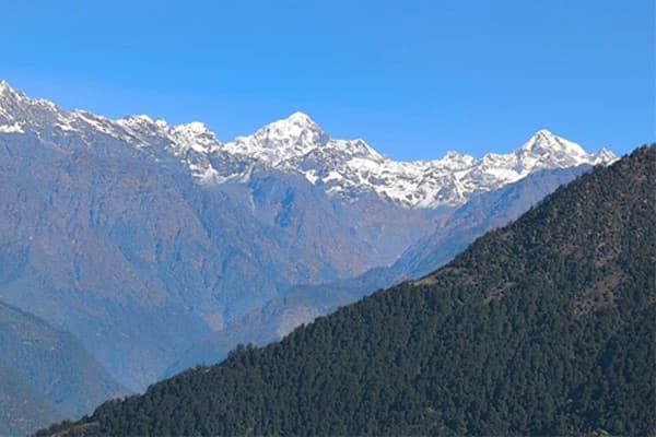
Panorama Mountain Views
Here are some of the iconic 360-degree panorama mountain views that the trekkers get to see from the key viewpoints, showing the world's highest peaks above 8000 meters.
- Everest (8848 m): The world's tallest fish lense view, that dominates the sky, from Renjo La (first high pass), and Kala Patthar, the highest altitude, which also accompanies you throughout the trip.
- Lhotse (8516 m): South face insight from Cho La and Kongma La, and also, the base camp of Mount Everest itself.
- Makalu (8485 m): Sharp, isolated, unique profile from Kong Ma La's rocky tip point unobstructedly, amid the colourful prayer flags.
- Cho Oyu (8188 m): Legendary gigantic frames, especially Renjo La, with foreground and upfront glacier vista.
- Nuptse (7,861m): Rugged ridge shields Everest, visible across all passes and EBC approach.
Ideal Seasons
Spring (March to May) and autumn (September to November) stand out as the best times for trekking to 3 high passes since weather conditions remain consistent and visibility reaches its peak. The main advantage? You can expect safe trails since the area experiences no rainfall and stays free from heavy snow or high humidity conditions. Springtime brings rising temperatures and beautiful rhododendron flowers to create white, red, and pink colour displays across the lower region.
Autumn delivers stable weather conditions, which allow you to witness spectacular mountain views during clear days with bright blue skies. You can also enjoy the local festivals like Dasain and Tihar that add a unique cultural charm to your journey. The daytime temperatures allow for comfortable walking conditions, but temperatures become cold during nighttime at high altitudes.
Pre-Monsoon (Spring) vs. Post-Monsoon (Autumn)
Here is a quick comparison of the two ideal seasons, Spring and Autumn, with weather, climatic conditions, trail situations and major cons and pros for 2026, and the reasons why it is considered peak times, over winter and monsoon months.
| Aspect |
Spring |
Autumn |
| Weather |
Mild days, longer sunlight hours, and moderate humidity to trail along |
Crisp, clear skies, cooler, chill nights, fresh air, low chances of any precipitation (rain or snowfall) |
| Temperature |
10-18 (daytime) and 0-4 degrees Celsius (night) - lower sections, whereas at high altitude, it does not fall below -15 °C |
10-15 °C (day) and 0 to -5 °C (night), low altitude, below 4000 meters
-10 - 0 °C during the day, -20 to -14 °C at night
|
| Weather |
Rhododendron blooms, excellent mountain views and occasional haze |
360-degree Himalayan peaks, golden landscapes, and grown millets at agricultural farms |
| Trail conditions |
Dry terrains, very few crowds early |
Dust-free, fresh mountain air and dry, stable terrains |
| Crowds |
Moderate, higher in May |
High in October, but gets quite at November, as winter arrives |
| Accommodations |
Wide variation, but prior booking is required |
Same |
| Festivals |
Buddha Jayanti (Sherpa New Year), Everest Base Camp Marathon in late May, and summit day (May 29 - honouring 1953 Everest climbers, in Namche and Gorakshep |
Major festivals (Dashain and Tihar) - mid Sep to Oct and Mani Rimdu: Late Oct or early Nov |
| Pros |
Greener landscapes, blooming flora and an encounter with elusive wild fauna |
Unhindered clear views, no chance of cloud burst, offering stable passes |
| Cons |
Pre-monsoon clouds (possibility only) |
Chilly starts and a heavy crowd |
Challenges during off-seasons: What to expect in winter and monsoon?
Passes remain covered in snow throughout the wintertime (December to February) and are often dangerous due to freezing temperatures that might block passage. The summer months (June to August) bring heavy monsoon rains and obscured mountain views due to clouds, while trails become muddy and slippery.
Winter Challenges
- Extreme cold, at high altitude, especially at the passes, the temperature takes a massive drop to -18 °C and -25°C at nighttime, risking frostbite and even altitude sickness for beginners.
- The trail gets covered with deep up to 3 ft snow, demanding crampons, ice axes, and prior experience, making the terrain 10x more challenging.
- Due to the heavy precipitation, the lodges usually get closed, and as the trail becomes strenuous, there are fewer guides and porters available - if hiked independently.
Monsoon Challenges
- The terrains get slippery, and leeches and mosquitoes fill the lower route, with high snow blockage at high passes.
- Risky on Khumbu Glacier moraines, flash floods block paths near Gokyo, especially.
- Poor visibility of the mountains.
- High possibility of Lukla flights, with 50% cancellation for a day, due to heavy rainfall.
Permits and Access: How to reach the Three High Passes Trailhead?
Required Permits
The two essential permits are: Sagarmatha National Park Entry Permit (3,000 Nepali Rupees/about $23) and the Khumbu Pasang Lhamu Rural Municipality Entrance Fee (2,000 Nepali Rupees/about $15). Trekking packages often include the price for permits among their expenses. The permits require both passport photos and a copy of your passport. These permits can be obtained either at Kathmandu, Nepal Tourism Board (NTB), located at Thamel, or at Monjo, at the national park gate itself. Even if you do the full circuit, including EBC as well, the required trekking permits remain the same. To know more info, check our detailed guide on Everest Trekking Permits, which completely overviews everything you need to know about the paperwork, processes, and documentations.
Getting to the Trailhead: Lukla Flight and Alternative Options
- Regular Lukla Flight: The standard route to Three Passes begins with a brief 30-minute flight between Kathmandu and Lukla airport, which provides exceptional views of the mountain peaks. The price of flying to Lukla from Kathmandu is part of standard trekking packages, together with the cost of the Lukla to Kathmandu flight. The trek flights operate based on weather conditions, thereby causing occasional delays which require a flexible itinerary.
- Helicopter option: However, if you are someone who has limited time and does not want the hassle of the flight to Lukla, delays or cancellations, then you can choose the helicopter option to get to the starting and ending point - Lukla Airport, with an additional fare. Or, you can commence the journey on the regular flight first, and the trip, from Lukla to Kathmandu, via helicopter, which promises to be time-efficient and shows the impeccable aerial mountain views from the top.
- Salleri/ Jiri Route: For those seeking to avoid the flight or airway option, can opt for the roadway route, via Jiri and Salleri, where you can reach the starting point by jeep, sharing bus, or private vehicle, avoiding the air navigation. The Jiri is the classical route, which demands an extra 1 week, just to get to Phakding via Lukla. It is an effective option for hikers who also want to know about the Sherpa culture of the lower Solu Khumbu region, but it can be demanding on time, taking 25-28 days in total. Whereas, you have another option, starting the trip from Salleri to the Everest Three Pass Trek, followed by two days, via jeep ride and continuing the walking route via Phakding.
Logistics
The trekking packages from an authorised trekking agency like Destination Himalaya Treks provide you with tea house lodging, which run throughout the trekking route with simple amenities and shared dining areas. The travel packages provide all meals, which include breakfast and dinner at the tea houses and lunch at eating spots along the trail. The demanding journey requires guide and porter services, which all packages provide. A guide provides direction and arranges logistics while watching your health and giving you insights about the destination. The porters will handle most of your equipment so you can walk with just a minimal day pack loaded with water bottles, snacks and your personal belongings.
Everest Three High Pass Trek Itinerary for 2026 and 2027
Here is a quick recommended standard itinerary of the adventure, to the legendary three high passes, with great acclimatisation days set in between, gradual ascent, and exploring/covering every highlighted corner.
- Day 01: Arrival in Kathmandu and transfer to the hotel
- Day 02: Take a flight to Lukla (35 mins) and then begin the walking trail towards Phakding (2640 m), a 3-hour hike only.
- Day 03: Hike to Namche Bazaar, the bustling and also the capital city of the Everest region, 4-5 hrs, at an altitude of 3440 meters.
- Day 04: Acclimatisation - Rest Day at Namche Bazaar, Side Trip to the world's highest altitude 5-star, Everest View Hotel, or Khumjung village
- Day 05: Hike to Thame (3772 meters), 06 hours approx.
- Day 06: Thame - Lungden at 4450 m, 5-6 hours
- Day 07: Trek to Gokyo Lake after crossing Renjo La Pass (5352 m), 07 hrs
- Day 08: Rest - Acclimatisation Day at Gokyo, with a hike to Gokyo ri view point (5357 meters), 03 hrs
- Day 09: Hike to Thangnag (4751 m), 4-5 hrs
- Day 10: First cross Cho La Pass at an altitude of 5420 meters, and then, hike to Dzongla, 6-7 hrs
- Day 11: Hike to Lobuche - rejoin the route of the base camp (3-4 hrs)
- Day 12: Lobuche - Gorakshep, and continue the hike to Everest Base Camp (EBC) at 5364 meters, 08 hours approx.
- Day 13: Early Morning Hike to Kala Patthar (5545 meters), and downhill trail to Lobuche, hike lasts for 3 hrs
- Day 14: Lobuche - Chhukung (4760 m), with a cross over of Kongma La Pass at 5535 meters, 08 hours
- Day 15: Chhukung - Tengboche (3865 m), 06 hrs approx.
- Day 16: Tengboche - Monjo through Namche Bazaar, 6 hrs approx.
- Day 17: Monjo - Lukla village
- Day 18: Get back to Kathmandu via Lukla flight
- Day 19: Final Departure Day
Major Highlights and Acclimatisation
Every trekker who takes on this trek creates life-changing memories because of its spectacular views. Two designated rest days are scheduled at Namche Bazaar and Gokyo for participants to spend time at the same altitude level. The extra days allow you to perform brief elevation hikes before returning for rest. The rest days at Namche Bazaar and Gokyo allow you to experience picturesque villages while appreciating stunning scenery, as your body adapts to future high-altitude pass journeys.
Iconic Viewpoints
The highest point of the entire trek reaches 5,545 meters in elevation at Kala Patthar, where you can view Mount Everest with perfect clarity. Standing opposite Everest, this dark rocky ridge provides unobstructed sight of the entire mountain from its base to its peak. Traversing from Gorak Shep to Kala Patthar requires about 2 hours of climbing through a steep terrain that takes you to the top to see Nuptse, Lhotse and Everest alongside the Khumbu Glacier underneath.
You can enjoy a breathtaking mountain panorama from Gokyo Ri (5,357m) that shows Everest alongside Lhotse, Makalu and Cho Oyu among the four highest peaks in the world, along with a magnificent view of the blue Gokyo lakes and Ngozumpa Glacier. Most hikers say Gokyo Ri gives better mountain view panoramas than the vista from Kala Patthar. But hey, you can be the judge later!
Everest Base Camp(EBC) and Gokyo Lakes
Mount Everest Base Camp sits at 5,364m just below the crown of Mount Everest, which stands as Earth's tallest mountain. From this viewpoint, you cannot catch a peek of Everest's summit, but you can witness the threatening Khumbu Icefall where climbers commence their ascent. During climbing season, the actual camp rests on the Khumbu Glacier with colourful tents and prayer flags. The experience of walking on this glacier creates an otherworldly sensation because it shows ice formations alongside glacier dust-covered rocks.
The Gokyo Lakes consist of five high-altitude turquoise lakes that exist at an elevation of over 4,700m, thus placing them among the highest freshwater lakes in the world. All in one location! The sacred lakes are encircled by snowy peaks, which create mirror-like reflections across their still surface during calm weather. And you'll be amazed to see ducks swimming around. Yep, even above 4,700 meters! A stroll through these lakes provides you with quiet times away from active trekking paths.
Village Exploration
During the trek, you will explore numerous Sherpa settlements that extend across the Everest region, where each village shows how people over many generations have adjusted to mountain living. The villages provide accommodation for resting, with options to learn about local culture alongside opportunities to taste traditional foods while encountering friendly mountain inhabitants.
Namche Bazaar functions as a top Sherpa settlement throughout the region, and it provides crucial acclimation opportunities, which are nestled in the mountainside. Do you know that it is shaped like a horseshoe? Yes, and features remarkable buildings where people can enjoy freshly baked goods at cafes, followed by a renowned Saturday market. You can experience Sherpa culture at the museum and gaze at Everest from the Everest View Hotel or unwind with hot chocolate.
The beautiful farming village of Dingboche has its land divided into sections for potato cultivation and yak grazing pastures by stone barriers. From its valley location, the village delivers spectacular views of Ama Dablam mountain and offers the chance to climb Nangkartshang Peak for stunning mountain views.
The traditional village of Thame lies at a distance from the main trail of EBC, and it is the birthplace of several Sherpa mountaineers, including Tenzing Norgay, who first achieved Everest's summit with Edmund Hillary. You can visit the historic monastery situated above the town that faces the ancient village and watch the stunning views of the mountains.
The small town of Gokyo sits next to the third Gokyo Lake and offers a peaceful atmosphere while standing at its high-altitude location. From here, you can climb Gokyo Ri while also visiting both the upper lakes and massive Ngozumpa Glacier.
Comparison with other Everest Region Treks
Among all the trekking options in the Everest region, this 3-pass adventure stands as the most demanding and extensive adventure. The 18-20 day itinerary leads hikers through a distinct circular route that spans across Renjo La (5,360m), Cho La (5,420m), and Kongma La (5,535m). During this journey through Everest, you will discover Gokyo Lakes and Everest Base Camp, along with Kala Patthar viewpoints and numerous traditional villages. This demanding trek extends over many days across a wide range of landscapes before granting you its most expansive viewing possibilities. This trek suits pro hikers who want to experience all the prime spots in the Everest region while bypassing popular trails.
The Gokyo Lake Trek presents a shorter adventure focusing on the mystical blue lakes situated within the Gokyo Valley. The 12 to 14-day hiking adventure lets you experience mountain vistas without encountering heavy crowds. Climbing up Gokyo Ri to 5,357 meters will reward you with spectacular views of Everest, Lhotse, Makalu, and Cho Oyu mountains. This trek fits people looking for quiet natural landscapes aside from Everest Base Camp, but not requiring access to Base Camp itself.
Among all trekking routes in Nepal, the Classic Everest Base Camp Trek stands as the most favoured option by tourists all over the world and takes 12 to 14 days to access Mount Everest Base Camp. The Khumbu Valley reveals its famous path to Namche Bazaar along with Tengboche, as it leads hikers to the Sagarmatha National Park. During your journey, you can reach the summit point of Kala Patthar for perfect Mt. Everest views before proceeding to Base Camp, which serves as the starting point for summit attempts by mountaineers. Many guest houses have established this trail, so it remains comfortable despite heavy foot traffic during peak months. The trek features an up-and-back journey on one path instead of a round journey and therefore works well for first-time Nepal trekkers.
The Everest Base Camp Trek Via Gokyo Lake merges two famous trails into a complete 16-18 day journey as it starts with a visit to the tranquil Gokyo Lakes, followed by a difficult crossing of Cho La Pass to access the main Everest Base Camp trail. By combining two routes, you get the peaceful ambience of Gokyo and the exciting experience of reaching Everest Base Camp. This journey represents a challenge above a regular Base Camp Trek because of its high pass, although it remains easier than all three passes combined.
The Gokyo Lake and Renjo La Pass Trek takes between 14 and 16 days to complete its route through the western section of the Everest region. During this trek, you will see the stunning Gokyo Lakes while walking across Renjo La Pass, which is famous for it stunning views of Everest and other peaks.
From crossing the pass, you will continue to the sparsely visited Thame Valley. This trek provides high mountain thrills and minimal crowds and delivers a satisfying adventure between basic treks and the challenging three-pass experience. Also, some people love to do only the EBC Gokyo Cho La Pass Trek that visits the base camp, six Gokyo lakes, and one of the high passes of Cho La- 5173 meters.
High Pass Challenges and Solutions
During this adventure, you will come across many challenges along the way, like altitude sickness, terrain difficulty, and weather challenges, during the cross over to the almighty passes of Renjo La, Cho La, and Kongma La, demanding prior preparations.
| Key Challenge |
Details |
Solutions |
| High altitude (Acute Mountain Sickness) |
While crossing all high mountain passes, above 5300 meters, the thinning air might cause a risk of AMS, such as headaches, nausea, vomiting, frequent pain, or a similar situation. |
- Acclimatise in Namche Bazar and Dingboche, including at least 1 acclimatisation/rest day in between.
- Follow the "climb high, sleep low" rule, take a gentle ascent, each day, gaining only up to 400 m, each day.
- Carry Diamox and an oximeter to measure the pulse rate.
|
| Technical Terrain |
Includes varied kinds of terrains, like glaciers, steep climbs, rocky moraines, and strenuous climbs to the mountain passes of Kongma La, Renjo La and Cho La, and hectic descents after climbing. |
- Navigate along with the trekking guide, throughout, follow his immediate, emergency calls, and do not hesitate to inform him if you feel any difficulties along the route.
- Carry technical gear, like crampons, trekking gear, even simple ones, which help to trek along.
|
| Physical Endurance |
6-7 hours long, walking distance, 600-700 meters altitude gain and fatigue, at 5500 meters. |
- Engage in cardiovascular exercises, such as running, walking, cycling, and swimming, for strength building.
- Slowly, level up your endurance via weight training.
- For beginners - if possible, at least do a day or 3-5 days hike near your city above 3000 meters.
|
| Weather Exposure |
High winds, sudden storms; -15°C+ wind chill |
- Layered clothing, windproof gear; check forecasts; avoid midday glacier crossings
|
| Navigation Dangers |
Loose rocks, landslide or avalanche sections |
- Do not hike independently, always walk along with guide, and do not leave your guide accompaniment.
|
Physical Preparation and Acclimatisation Tips: What you must consider before the trip?
- Initiate your training routine two to three months before the trek by stair-climbing exercises, hiking and walking activities to develop endurance.
- You should do cardio activities, including running, swimming or cycling, three or four times weekly to build both your lungs and heart strength needed for high altitude conditions.
- The challenging uphill terrain and steep passes require you to include leg strength exercises like squats, lunges and step-ups into your training.
- Trekking with a weighted backpack matching your final pack that carries the same weight helps your body adapt to the expected weight during the hike.
- During the trek, always maintain a steady walking speed and do not try to rush if you feel tired.
- Your daily water consumption should reach at least 3-4 litres because this hydration level protects you from altitude sickness.
- Rest days require short climbs toward higher elevations but sleep at locations with lower heights as part of the "climb high, sleep low" method.
- Acclimatisation days should never be skipped because your body needs each scheduled day to adapt correctly, despite feeling fine.
- Understand how to identify symptoms of altitude sickness by paying attention to headaches, feeling dizzy, losing appetite, nausea, sleeping problems and breathing issues.
- When experiencing symptoms, inform your guide right away and prepare for descent if your condition worsens.
Custom Itineraries or Group Discounts for 2026 and 2027
Trekking agencies will adjust their standard itineraries according to your preferences, so simply request changes when booking your travel to get either additional rest days, to include added destination stops or to shorten the trekking period. The companies prepare personalised routes based on your individual needs, like time and budget. When travelling with friends or family members, you can also get a special discount offer. Most trekking companies provide better rates to groups consisting of four individuals or more. The number of participants in your group determines how large the discount will be. A limited number of companies provide exclusive offers and reduced rates for off-season treks, too. Most trekking companies expect queries about price modifications or better offers, and they will gladly assist you in creating your ideal trek experience.
Contact us at Destination Himalaya Treks and Expedition for a custom itinerary and group discounts for the best price!
How to book this expedition?
You can easily arrange your 3 Passes Trek booking. Choose spring or fall seasons for your trekkers because they provide better weather conditions, and review multiple trekking companies online to study their reviews from trekking clients. Review their plans to confirm the inclusion of permits, both Lukla flights, meals, and accommodation in their quoted price. After selecting your preferred company, you should complete their booking form or contact them by email. They will need some personal details and a deposit equal to 20% of the total expense for securing your trekking slot, and allow you to finalise your payments upon your arrival in Nepal. The booking process for the trek starts at least 2-3 months ahead to secure your spot, particularly when you choose peak seasons.
You can email us at info(a)destinationhimalayatreks.com for the booking confirmation, or you can phone or message us on WhatsApp at +977 9851016814 with any questions. To manage everything, we just deduct 20% of the entire fee; the remaining sum may be paid after you get to Kathmandu. We are also open for last-minute bookings, so do not hesitate to contact us as we are here to assist you at all times!