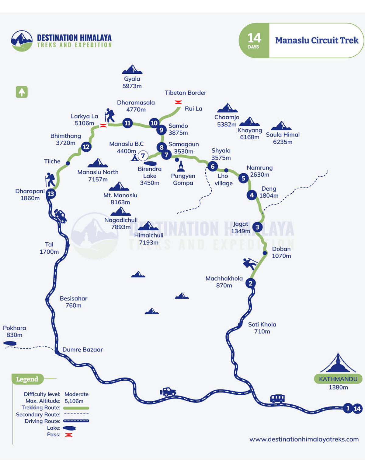
The Manaslu Circuit Trek Map serves as your ultimate navigation companion, your best buddy, to venture out on such a remote, restricted, and isolated trail in the Himalayas. Starting from Maccha Khola (930 meters), or Soti Khola via Aarughat, the trail of the Manaslu Trekking covers a distance of almost 177 kilometers, passing through several Tibetan authentic hamlets, such as Jagat, Deng, Namrung, Shyala, Lho, and the acclimatization high points at Samagaun and Samdo, which take you to the iconic spots such as the lap of the world’s eighth tallest peak, Mount Manaslu - Manaslu Base Camp, one of the highest altitude lake, at Birendra Lake, and Tibetan Border (Rui La Pass) before attaining to the highest elevation of Manaslu circuit, Larkya La Pass at 5106 meters and descending to the concluding points, Dharapani, Tilije and Besisahar.
The map of the Manaslu Circuit Trail showcases the daily altitude gain, daily distance coverage, and alternative routes, or linkage of the route with other famous popular destinations, ike Tsum Valley, or the Annapurna Circuit (Thorong La Pass), so that you can make the planning and be prepared accordingly. It also reveals the daily elevation shifts from 930 meters to the highest altitude Tibetan villages (highlands), the river crossings, tea house stopping points, and optional side trips, which you can include on the itinerary. Reviewing the Manaslu Trekking route map, guides to build confidence, plan the pace of the hike daily, and total duration of the adventure, plot the acclimatization days, and dodge the road works, landslide, or avalanche areas via GFX enhanced details, for safe and smooth navigation.
No matter whether you are an experienced or a beginner, a clear and detailed map entails a safe navigation, a plan, and being prepared, giving you full feasibility to craft the itinerary, matching your pace level, and highlighting spots, ensuring a hassle-free odyssey.
Why the Manaslu Circuit Trail Map is important for every hiker: 5 Reasons why?
The trekking map of Manaslu Circuit, which tends to be one of the most remote, isolated and restricted routes in Nepal, acts as your buddy, not only guiding you for safe navigation, but also letting you unravel the hidden treasures along the route. When you compare this trekking trail with other popular routes like Annapurna Base Camp or the iconic Everest Base Camp (EBC) Trek, you will find that this trail is more undeveloped, off beaten route, less crowded, and covered with only limited tea houses, and lodges, making it more, hazard expedition to proceed, if you are completely unaware of the route, especially, when you are considering a solo hike even though it's not possible.
The route is isolated as well, and comprises varied kinds of terrains, for example, if the journey begins from a forest trail, soon after the walking trail begins, from Maccha Khola, it goes deeper forest route, with no signboards, until you reach the concluding point - Jagat. As the day proceeds, the trail gets more intense in terms of difficulty, more remote with limited facilities, and fewer encounters with locals, beyond Samdo, Samagaun, en route to Larkya La Pass, which makes the trail more frustrating and confusing to those who have never been to the region. Besides, if you have got a trail map, along with you either hard copy, book, or even screenshot of our Manaslu circuit trail map, displayed below, it helps you monitor, on the distance, elevation gain, and locate evacuation key points, for an evacuation, or also, engage in side trips, if you are considering to lengthen your itinerary.
Not to exaggerate more, here are the top 5 reasons why the map of the Manaslu Trail route stands out as a crucial aspect for every kind of hiker, no matter how noob or experienced you are:
Safe Navigation: Assists you through the trails that do not have markings (signboards), and prevents wrong turns, due to confusion, through isolated, remote sections, acting as a buddy, throughout the adventure.
Plan and Locate Tea houses (Key Points): Guides you to plan where to stop by, where not to, set acclimatisation days, and craft the itinerary, matching your prior trekking experience, daily hiking pace level, and also, locate tea houses (lodges), major stops, such as Jagat, Deng, Samdo, etc., to accommodate at.
Daily Distance Measurements: Shows how long your hike is gonna be, the daily distance coverage tends to be between 8 and 12 kilometres; however, you can set a slower pace, or a rapid pace for safe navigation, considering the total 177 kilometres walking trail circuit loop.
Not to Miss out Side Trips: Outlines, iconic side acclimatisation hike from Sama gaun to Manaslu Base Camp or Birendra Lake, and Samdo towards Tibetan Border (Rui La Pass).
Awareness of Hazard Trail: Highlights the dangerous sections like landslide areas, dense remote routes, avalanche chances, and river trackings, that have the challenges of flood or any steep trail bridges.
Manaslu Circuit Trek Map: 14 Days Day-to-Day Route Breakdown with Distance
Here is an insight into the standard route of the Manaslu Trek, which follows the regular trail, counterclockwise route and undertakes a gradual ascent each day, without going over the pace, ensuring safe navigation and coverage of every highlighted corner of the trail, without missing out on any gems. It is crucial to know the detailed information about the route optimisation, distance and hiking pace coverage daily, and also, an insight into the route, which we will discuss below.
Standard Manaslu Circuit Trek Map
Day 1: Kathmandu to Maccha Khola, via Soti Khola and Aarughat, with a drive of 7-8 hours: Reaching the starting point of the trip
The first day basically marks a drive (roadway navigation) from Kathmandu (capital city of Nepal), passing through many highways, bustling towns, transition of the lush green valleys and landscapes along the roaring Trishuli River. The drive first takes you to Aarguhat (where you must change the local bus to a jeep), then follows a bumpy ride to Soti Khola and then Maccha Khola.
Distance: 160 km (98 miles)
Duration: 8-9 hrs
Walking Hours: Only 15 minutes ascent to the tea house
Day 2: Maccha Khola (936 m) to Jagat (1342 m)
Navigation along the Budhi Gandaki River also marks the first walking trail, which mostly passes through the forested area of rhododendrons and Sal forest, crossing several bridges in between and Tibetan villages of Kholrabesi - Tatopani (hot spring) - Thulo Dhunga (Yeni) - Thado Bharyang (Salleri).
Distance: 20 km (11.69 miles)
Walking hours: 8-9 hours
Elevation Gain: 406 m
Day 3: Jagat (1342 m) to Deng (1906 m)
Asends towards north western side, passing mostly through bamboo forests, and some landslide-prone areas as well, with small hamlets, Sridibas- Primo - Phillim - Dyang villages
Distance: 21 km (12.3 miles)
Duration: 8-9 hrs
Elevation Gain: 564 m
Day 4: Deng (1906 m) to Namrung (2630 m)
Navigates along the Budhi Gandaki Valley, crossing many suspension bridges, the Tibetan-influenced route widely opens up, via mani walls, chortens, and settlements of Bihi Phedi - Bihi - Prok - Ghap - Rana - Namrung village, with more prominent insight of the world's tallest peak - Mount Manaslu (8163 meters).
Distance: 19 km (11.6 miles)
Duration: 8 hours
Elevation Gain: 726 meters
Day 5: Namrung (2632 m) to Lho to Shyala village (3426 m)
More uphill walk, and traverses through bamboo, forest trail, with a view of Simnang Himal and Ganesh Himal, passing Tibetan villages of Sho - Lho - Lihi - Shyala village, from the insight of the Ngadi Chuli and Manaslu Peak.
Distance: 14 km (8.9 miles)
Duration: 5 hrs
Elevation Gain: 794 m
Day 6: Shyala to Samagaun (3530 m) via Pungyen Gompa
Visits one of the most ancient and oldest gompa (Pungyen Gompa) along the trail, via the side moraine of Pungen glacier, and the main resting points of Yak Kharka, before reaching Samagaon (Samgaun), known as an acclimatisation stop, with important side trips, and must have, to adopt rising altitude beyond this elevation (upcoming days).
Distance: 16 km (9.4 miles)
Duration: 4 hrs
Altitude Gain: 106 meters
Day 7: Rest - Acclimatisation Day at Sama Gaun (Optional - Manaslu Base Camp or Birendra Lake)
Choose either Manaslu Base Camp or Birendra Lake, as your time and hiking pace match
Day 8: Samagaon (3530 m) to Samdo (3876 m)
Short yet meaningful trail, that takes you closer to the Tibetan border, entering a woodland area, the route is more tibetan influenced side, and follows a rough and rugged pattern more. Another major acclimatisation point, before crossing the pass of Larkya La.
Distance: 6 km (3.7 miles)
Duration: 2-3 hrs
Altitude Gain: 316 m
Day 9: Acclimatisation Day at Samdo, Hike to Tibetan Border (Rui La Pass)
Reach the Tibetan Border at 4720 meters
Day 10: Samdo (3876 m) to Dharamsala (4770 m)
Alongside the Athahra Saya River, the Larke River via Taka Choeling Gumba, the Larke Bazaar (Dharamsala finally known as the base camp of Larkya La Pass.
Distance: 6 km (3.6 miles)
Time: 3 hrs
Elevation Gain: 894 m
Day 11: Dharamsala - Larkya La Pass at 5106 meters - then descend to Bhimtang (3570 m)
The most challenging and longest trail, with a massive transformation from rugged landscape to the snow-frosted mountains and alpine valleys, covers almost 22 kilometres, with 9 to 10 hours of hiking.
Distance: 22 km (13.67 miles)
Time: 9-10 hrs
Elevation Gain: 1536 meters
Day 12: Bhimthang (3570 m) to Dharapani (1860 m)
Touches the ending point of the trip, and walking trail navigation. The hike follows a complete downhill descent navigation trail, via a forest area.
Distance: 20 km (12.6 miles)
Time: 7-8 hrs
Elevation Loss: 1710 m
Day 13: Getting back to Kathmandu or Pokhara from Dharapani directly or Tilije village
End the adventure with a drive back to either capital city, Kathmandu or the city lake - Pokhara.
Note: The displayed Manaslu Circuit Trail Map also includes the arrival day of you, in Nepal, however, excluding that part, 1 Day, on this overview, this day-to-day itinerary starts directly, with a jeep drive from Kathmandu to Machha Khola via Aarughat and Soti Khola, and ends with getting back to Kathmandu.
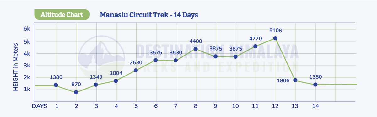
The Manaslu Circuit Trek map significantly showcases the gradual elevation gain, following the total trekking distance of 177 kilometres, that starts from Kathmandu (1380 m), and then proceeds with the walking trail, from Maccha Khola with an altitude of 870 meters, alongside Budhi Gandaki River, and a forested trailhead, passing some of the notable spots like Jagat, Deng, Namrung, Shyala, Lho village, Sama gaon, Samdo, Dharamsala, and then, crosses the highest pinnacle at Larkya La Pass (5106 meters), and follows, the downhill walk, again following the Sal Forest Trail.
You can find a detailed list of the villages on the Manaslu Circuit altitude map
Key Point
Elevation (In Meters)
Kathmandu
1380 m
Maccha Khola
870 m
Jagat
1349 m
Deng
1804 m
Namrung
2630 m
Shyala
3575 m
Sama gaon
3530 m
Manaslu Base Camp or Birendra Lae (Acclimatisation Hike)
Max. 4400 m
Samdo
3875 m
Acclimatisation Hike to Rui La Pass (Tibetan Border)
4720 m
Dharamsala (base of the Larke Pass)
4770 m
Larkya La Pass
5106 m
Bhimthang
3720 m
Dharapani
1860 m
Kathmandu
1380 m
Manaslu Circuit Elevation Profile
To know more regarding the distance and elevation, on a day-to-day basis, you can explore our guide on Manaslu Circuit Distance and Elevation Profile, that overviews an overview of the overall insight of the route and trailhead, as well.
Essential Trail Highlights on the Map
Lasting for 12-14 days, the Manaslu Circuit Map follows a completely counterclockwise route that starts from Maccha Khola and ends at Dharapani, covering the distance of 177 kilometres, and encircles the world's tallest peak, Mount Manaslu, alongside Budhi Gandaki Valley and roaring rivers. The journey takes you into six climatic zones, from forest trail navigation, to rugged and remote sections, to higher alpine valleys, to the pinnacle of the Larkya La Pass, entering the restricted trail of Manaslu Conservation Area, from the beginning till the end, demanding a restricted area permit. Apart from just the insights and day-to-day route map update, here are the major essential trail highlights on the Manaslu Trek Map, so that you get an overview of what the major attractions are to expect along the route.
Iconic View Points and Panorama Mountains
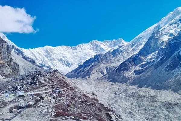
The trailhead takes you to many iconic viewpoints, such as high-altitude villages, like Samdo, Samagaun, Lho, Namrung, and many others, where, throughout the trail, some of the legendary peaks, such as Ganesh Himal, Himalchuli, Himlung Himal, Kang Guru, Annapurna II, and Mount Manaslu (8163 meters) in each stride. Besides, you can encounter the vista of the mountains and landscapes, from many vantange point beyond 4500 meters, during side trips, like Rui La Pass (Tibetan Border), Birendra Lake, one of the highest altitude lakes, named after King Birendra, and the lap of the world's 8th highest peak, Mt. Manaslu - Manaslu Base Camp, with 360 degree views of glaciers, peaks, rugged and tibetan influenced landscapes, etc. Whereas, the highest point of the standard circuit stands out to be the Larke La, which unravels the massive, gigantic peaks of the Mt. Manaslu along with the Annapurna range, flanked by the fluttering buddhist player flags.
Cultural Transition Zones
This trek is more focused on the cultural and tea house experience, where, being located at one of the most isolated protected remote areas of the Himalayas, the route navigates via several villages, and lodges run by the locals themselves, who are officially of Tibetan origin. As you can see on the trail map itself, each day, the trail takes you to the hamlets of diverse communities, and each day that passes by unravels the unchanged cultures and traditions of the distinct ethnic groups.
While the lower highlands from Macchakhola (870 m) to Jagat at 1349 meters, the trail is covered by Hindu communities, like Brahmin, Chhetri, Newar, and others, whereas, as you reach higher elevation, Namrung, Shyala, Samagaon, Samdo, you can get more Tibetan authentic cultures featuring Gurung, Tsumba, Sherpa communities, following Tibetan Buddhism culture. Besides, other unmarked (undisplayed) hamlets like Rana, Ghap, and many others are more covered by the Gurung, Nubri cultures, which are beyond standard GPX files.
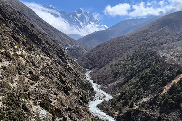
Rivers and Bridge Crossings
The trail passes along the Budhi Gandaki River, right from the very beginning of the navigation, crossing over several suspension bridges above. The roaring river will accompany you on many stops, especially between the trail of Maccha Khola and Jagat via Khorla Besi. Besides, there are two main prominent long bridges, between Khorlabesi and Tatopani (hot spring), and between Hagat and Salleri (1460 meters), which fall under the beginning part of the trailhead, the Budhi Gandaki, typically fades after you cross the elevation above 3000 meters, from Namrung at 2630 meters.
Acclimatization Points
The Manaslu Circuit Trail includes two main acclimatisation points, one marked to be Samagaon (3,530 meters), which takes you to the most popular vantage points of Manaslu, firstly, the Birendra Lake, and another tends to be the Manaslu Base Camp (the foothill of one of the eight thousanders), as these spots grabs one attention, the map of the Manaslu Trek, now includes, these side trips, mostly in updated one. Another key acclimatisation point stands out to be Samdo (3875 meters), which is closer to the Tibetan border, and also sits close to the base of Larkya La Pass, which is basically not included in many itineraries. If the map is not updated, however, one can consider this acclimatisation and a side trip to enhance the overall destination.
Permit Verification Stops
Jagat (RAP entry), Deng, Namrung, Samdo, layer these checkpoints directly onto your Manaslu circuit trail map for legal compliance visuals, stressing guide requirements. The permits might get checked at other points as well, so make sure to carry your two required permits, the Manaslu Conservation Area Permit (MCAP) and the Restricted Area Permit (RAP), throughout the trailhead.
Road conditions on the Manaslu Circuit Trek have evolved significantly due to hydropower-driven construction, extending vehicle access from Kathmandu while altering early trail segments.
Manaslu Circuit Trek Road Condition: Updated Information
Compared to old routes, back to 8-10 years, the road construction has transformed the traditional route of the Manaslu circuit, the overall dynamics of the trip, and has shifted the starting point and ending point, minimising the overall trek by 1-2 days. The classic route back then used to begin from Aarughat or Soti Khola, with a public local bus ride and ended directly at Dharapani - Besisahar. In the present day, you can take a bus to Aarughat and then grab a private or shared jeep, following the bumpy road, as the road condition is still rugged, and start the walking trailhead, from directly Maccha Khola, or Jagat, skipping 1-2 more days, and then, end the trail, at Tilije or Dharapani that links the standard trail of the Annapurna Circuit route as well.
Beyond, Maccha Khola, there is no public vehicle, updated, till 2026, now, however, you can take a private jeep upto Phillim (passing Jagat), if you want to shorten the trip, and commence on a short trek to Manaslu, however, starting from Maccha Khola is more safer, rather than, directly gaining such massive high altitude in one day. Apart from that, the tea houses have now upgraded 4 G in Samagaun, and also, in the process of building more tea houses, with attached washrooms, so that hikers can get comfortable throughout the journey, whereas the sustainability and ecotourism initiatives are in progress to save the untamed beauty of the territory.
Manaslu Circuit Map Connection with other Destinations (Combined Trailhead)
The Manaslu and Annapurna Circuit Trail map demonstrates the trek linking the Manaslu Circuit with the Annapurna territory, circuit, from Dharapani, where the route of Manaslu route basically concludes, which provides an opportunity to unravel the majestic beauty of the Himalayas, and also, cross both the thrilling iconic pass of Larkya La (5016 m) and Thorong La Pass at 5416 m, which is known as the world's highest/longest passes.
Starting the journey, from Maccha Khola, the trail, in the first half, passes via the iconic villages of Jagat, Deng, Samagaon, Samdo, and crosses the pass, along the Budhi Gandaki valley, and then, touches the route from Dharapani, touching the route of the Annapurna circuit, proceeding towards Chame, Upper Pisang, Manang, Yak Kharka, alongside Marshyangdi and attains the pinnacle of Thorung La Pass, and descends along the Kali Gandaki valley. The Gandaki Valley connects with the Mustang region. Trekkers can use this insight for their next adventure, especially if they are planning a combined destination, overview, and itinerary, including acclimatisation, key stopping points, duration, and distance coverage of the trail, depending on their time and fitness level.
Manaslu - Tsum Valley Trail Connection
The Manaslu Circuit and Tsum Valley Trail connect via an eastern side from the main Budhi Gandaki Valley, where many hikers seek to explore the combined route, to explore more out of the Manaslu region, passing through remote, rugged and Tibetan-influenced landscapes, and alleys, mostly focused on a deep cultural Tibetan origin lifestyle near the Tibetan border. Starting from Soti Khola, or Maccha Khola, passing via Jagat, Deng, Phillim, it touches the trail of the Tsum route, through Phillim to Lokpa, Chumling, Mu Gompa, and highlights 5 Tibetan old monasteries, and then, connects with Deng, after descending from Chumling, and continues to continue the standard route of Manaslu.
Adding Tsum Trail adds more of a 5-6 days and then explores the deeply influenced Tibetan villages, monasteries, and more isolated and remote areas, which requires another permit called the Tsum Restricted Area Permit, along with other Manaslu Permits.
Tips for Using Manaslu Region Trekking Maps: Things to Consider
While buying the maps, at Thamel, or anywhere (physical or online stores), make sure whether the map is an updated version or not, as many knowingly or unknowingly, tend to sell maps of the 90's trailhead, which no longer supports the route in 2026.
Before departure, make sure to review the full route, noting daily distances, elevation gains, acclimatisation spots, and dangerous sections, so that you are aware of what to expect en route.
Locate the main tea houses (stopping key points), like Samagaon, Samdo, Jagat, Namrung, and mark them, and do not miss out contouring the hazard and challenging trails like Khorlbesi gorges, crossing Larkya La Pass, pacing the hike, towards Manaslu Base Camp (acclimatisation hike).
Check alternative points or the side trips, which you can include or exclude, as per your time frame, hiking pace, and experiences, so that, rather than being influenced by others, you can craft your own packages.
While reviewing the map, at the bottom line, it is clearly given the colours, symbols, or any patterns of route, which signify the trail, valleys, alpine zones, passes and so on, so to understand the map, first of all, check the bottom of the map.
Rather than relying on fully digital maps or GPS, it is better if you also carry paper maps, along with you, as they neither get misguided nor run out of battery, and both can act as a comparison or substitute.
Load routes into Maps.me or Gaia GPS for real-time positioning without signal - suggested to download offline GPX
Do the map readings with your guide, whom you have hired together, so that you can plan, considering alternative routes, or any optional side trips, on your itinerary.
FAQs (Frequently Asked Questions)
What is the total trekking distance of the Manaslu Circuit Trail?
In total, the Manaslu Circuit covers a distance of approximately 176 kilometres (110 miles), which is the walking trail only, starting from Maccha Khola and ending at Dharapani, and crossing the highest pinnacle of Larkya La Pass, within a 12-15 day timeframe. Meanwhile, some itineraries focused on completing the trek within a rapid or short timeframe, typically 8-10 days, starting from Soti Khola directly, which covers a shorter distance of 90 to a maximum of 110 kilometres.
Where can I download the Manaslu Circuit Trek map GPX?
You can download the GPX files on our own site at Destination Himalaya Treks, at the packages site mentioned in the Manaslu region, where the route map has already displayed, crafted by our expert teams, with a duration from 10-16 days, alongside trips included. Just go to the map, download, or screenshot it for feasibility. Or else, you can also download compatible apps with free live GPS tracks for more feasibility on Maps.me, Gaia GPS, and Google Earth.
Where can I buy trekking and topography detailed maps in Kathmandu before starting the trek?
You can find trekking maps of any kind regarding Nepal's mountains, landscapes, and himalayas, at physical book stores such as Vajra Books, Pigrims Book House, Himalayan Map House, or the local shops, near Mandala Streets, that are specialized in trekking maps, focused, only one region, like Manaslu, Annapurna or Dolpo region, or even overall, general map, of trekking trail. However, before you grab the map, make sure that it is published recently, and do not go for old maps for the Manaslu Circuit, as the route has been changed (modified) in many ways.
What villages are not marked on the Manaslu Circuit trail map?
Usually, smaller or lesser-known hamlets or villages, you cannot find or track them on the online maps or GPX Files, which only prioritizes, on the key points like Namrung, Jagat, Deng, Samdo, Samagaun, Bimthang, where you can settle and rest. Mostly, there are only standard maps available, which include acclimatisation spots, permit checking, stopping points, the main mountain, and the landscape range, overlooking small settlements like Ghap, Bihi Phedi, and other small points. Thus, if you want a full coverage map, then use local detailed map files, available at stores in Kathmandu or Pokhara (city areas).
What is the height of Larkya La Pass? Is it the highest point that the route includes, or are there higher elevations?
The highest point of Larkya La Pass stands at 5106 meters (16,754 feet), serving as the highest elevation of the standard trail route, where it is located between two points between Dharamsala and Bimthang. There are no other high point that exceeds this altitude, if followed by the regular trail of the Manaslu circuit route, which is also known as the ending point before descending to the ending point at Dharapani.
What are the major permit checkpoints of the trekking permits?
The main permit checkpoints of the Manaslu are the entry points like Jagat, Macchakhola, and Aarughat, before you enter the restricted area of the Manaslu region; however, the permits might get checked at any stopping points, so make sure to carry the permits throughout the trip. The required permits are the Manaslu Conservation Area Permit (MCAP) and the Restricted Area Permit, which can only be obtained from a local-based trekking agency.
If I have a detailed map, can I skip hiring a trekking guide and hike independently?
No, hiking to Manaslu Circuit in Nepal, without a guide, is simply not possible, as the trail falls under the restricted area, where the Government of Nepal has mandated the law that to acquire the required permits, one must have a licensed trekking guide, through local based travel agency like us, for a safe and secured navigation, along with tracking the inflow and outflow of hikers. Thus, no matter how experienced you are, what kind of GPS maps you've got, trekking independently is not allowed.
Conclusion (Final Words)
Before you venture out on any himalayan adventure, the first and foremost thing that you must consider is route planning and optimisation of the itinerary, especially on such remote and restricted trails as Manaslu. The Manaslu Circuit Trek Map emphasises elevating your adventure so that you get an in-depth insight into the exploration route include major side trips, without missing out on anything, and is a must-have essential, even if you trek with the guides, so you are well aware and also know where the next destination you are heading to.
Detailed information regarding mapping guides you through distance, elevation gain, villages, high passes, hidden valleys, and high mountains, which entails a complete overview and exploration of rich and untamed cultures of Tibetan origins, the meaning behind the monasteries, hamlets, most of all, undertake a smooth and easy going journey, with proper preparedness, about the route, and daily challenges, with perks and cons, that you are going to face helping you to get trained and be prepared accordingly.
This Manaslu region trekking map guide unravels more than just rugged terrains, mountains, high passes, routes, and the soaring elevation like Larkya La Pass (5106 m); however, it also tends to reveal the hidden gems, side trips, Gurung and Tibetan hamlets, and communities thriving in some remote and isolated alpine valley, above 3000 meters. Well, are you geared up to conquer the thrilling Manaslu circuit and attain the pinnacle? Then, dust off your hiking boots, leave your bed, comfort zone, or 9 to 5 job for a while, and secure your bookings with Destination Himalaya Treks and Expedition. At us, you will find expert guidance, seamless logistics arrangements, best route navigation, and assistance of the experienced licensed trekking guide, who is medically trained and equipped. For further queries, feel free to contact us anytime.